New Strategy for the Survival of Southern California’s Wetlands

Chula Vista – Today (10/18/18), the Southern California Wetlands Recovery Project released its new Regional Strategy 2018, a science-based guide for the long-term restoration and expansion of Southern California’s coastal wetlands.
The Southern California Wetlands Recovery Project (WRP), a consortium of federal and state agencies, has been collaborating on wetlands preservation and restoration from Santa Barbara to San Diego for almost 20 years. The Regional Strategy 2018 is the culmination of four years of work to identify critical locations and best practices for the restoration of today’s wetlands, as well as the protection and enhancement of wetland-upland transition zones that may become tomorrow’s wetlands as a result of sea level rise.
Wetlands support abundant wildlife, clean water, carbon storage, flood protection and are often the only natural spaces remaining within the Southern California coastal urban matrix. Southern California has already lost 62% of its 33,400 acres of historic coastal wetlands. Those that remain are mostly diminished, altered, and highly vulnerable to the impacts of sea level rise. Without intervention, an additional 800 acres will be lost after 24 inches of sea-level rise (expected by 2050) and a further 2,900 acres will be inundated by a 66-inch rise (expected by 2100).
The Regional Strategy 2018 establishes a plan to prevent further net wetland loss, and could result in up to 7,700 new acres of wetlands by restoring historic wetland areas currently isolated behind levees and dikes and by allowing sea level rise to claim low lying coastal uplands.
“Wetlands provide some of the most productive and beneficial habitats for wildlife, people and local economies. In urbanized Southern California, coastal wetlands are many times the only natural places available to people; they provide areas for reflection, respite and relaxation.” said Sam Schuchat, Executive Officer of the California State Coastal Conservancy, “The Regional Strategy 2018 is a realistic, implementable roadmap for projects throughout the region that will preserve and potentially expand these last remaining natural places.”
The strategy is comprised of four overarching goals:
- Preserve and restore resilient coastal tidal wetlands and associated marine and terrestrial habitats by facilitating wetlands migration and reconnecting fragmented systems.
- Preserve and restore streams, adjacent habitats, and other non-tidal wetland ecosystems to support healthy watersheds.
- Support education and compatible access related to coastal wetlands and watersheds.
- Advance the science of wetland restoration and management in Southern California.
The report was developed with the input of over 50 scientists and resource managers to analyze how wetlands have changed over the past 150 years, threats they are facing, and restoration and management opportunities that will ensure their long-term health. By bringing together scientists, government, and local organizations, the WRP has mapped potential wetland losses and identified high priority actions to restore them in the face of sea-level rise.
“The Regional Strategy 2018 is based on rigorous analysis of the region’s current wetlands and their surrounding environs to give a clear and comprehensive picture of the options for the future. Within each of the Strategy’s goals are quantitative objectives based on specific criteria that will help guide and measure our progress.” said Professor Christine Whitcraft, Director of the Environmental Science and Policy Program at California State University, Long Beach.
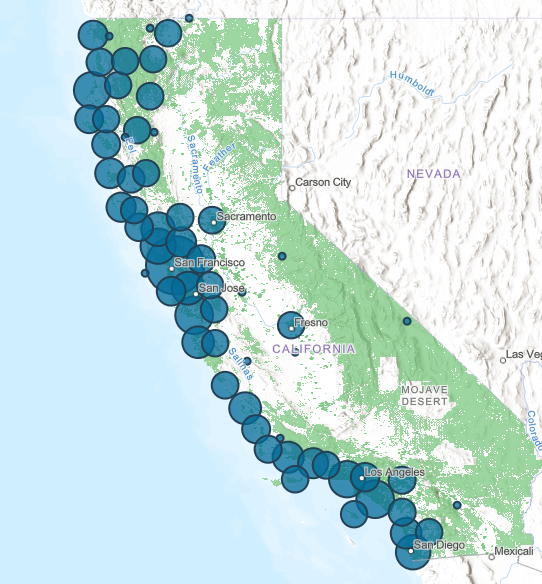
The objectives will be supported by the Marsh Adaptation Planning Tool (MAPT), a new mapping tool developed with the Conservation Biology Institute that illustrates and quantifies the ecological state and future potential of wetland zones. The WRP and its partners will use the MAPT to develop, evaluate and prioritize restoration projects. The MAPT is available at scwrp.databasin.org.
In addition to objectives for tidal wetland restoration, the strategy encompasses preliminary objectives for watershed health, recognizing that wetlands rely on stream and sediment flow. Coastal sustainability in the future will rely on sediment supply to nourish our beaches and wetlands, and the WRP’s objectives to remove impediments to water and sediment flow will highlight the necessity for projects that support this critical need.
Several key wetlands recovery projects are already underway in Southern California. The WRP will use the new Regional Strategy to assess and, if necessary, augment current projects and to guide its future work.
The Regional Strategy 2018 is available here.
The Executive Summary is here.
Notes to Editors
Wetland facts:
- Around 1850 there were approximately 33,400 acres of all coastal wetland habitats (subtidal, unvegetated flats and vegetated marsh)—not counting 14,948 acres of subtidal embayments such as San Diego Bay. In the following 150 years, more than 62% of these wetlands have been lost. By 2005 only 12,800 acres remained. Vegetated marsh has experienced the greatest absolute decline with a loss of 13,400 acres
- Wetlands are important habitats for wildlife, recreational spaces for communities, and effective buffers against sea level rise impacts.
- Without intervention, an additional 800 acres of coastal wetlands will be lost after 24 inches of sea-level rise (currently predicted by 2050) and a further 2,900 acres will be lost under the 66-inch sea-level rise scenario (currently predicted by 2100).
- With 24 inches of sea-level rise, 7,700 acres of current upland habitat could become wetlands if actions are taken to facilitate, or not impede, that migration.
- Wetlands restoration projects take approximately 20-40 years from planning to completion of a fully functioning wetland. Because of the rapidly increasing rate in sea-level rise in the second half of this century, wetland restoration should occur before 2030 in order to establish mature marshes that are more resilient to sea-level rise; such efforts need to start immediately.
About the WRP
The Southern California Wetlands Recovery Project (WRP) was created in 1997 as a regional voice for the valuable yet diminishing coastal resources of Southern California. Prior to the creation of the WRP, there was little regional coordination or communication between public agencies, nonprofit organizations, and community members who had a vested interest in Southern California’s wetlands.
Since our Working Agreement was signed on September 8, 1997 (amended December 11, 2017) by 14 state and federal resource directors and managers, the future of Southern California’s wetland resources has been much brighter. The WRP is a broad-based collaboration, led by the California Natural Resources Agency and supported by the State Coastal Conservancy and Earth Island Institute, that has public agencies, non-profits, scientists, and local communities working cooperatively to acquire and restore rivers, streams, and wetlands in coastal Southern California. The WRP’s geographic scope is from Point Conception in Santa Barbara County to the international border with Mexico.
Using a non-regulatory approach and an ecosystem-based perspective, the WRP works together to identify wetland acquisition and restoration priorities, identify funding to undertake these projects, and provide technical assistance to project proponents.
WRP Member Agencies:
U.S. Army Corps of Engineers
U.S. Environmental Protection Agency
U.S. Fish and Wildlife Service
National Oceanic and Atmospheric Association (NOAA) Fisheries
Natural Resources Conservation Service
California Natural Resources Agency
California Environmental Protection Agency
California Coastal Commission
California State Coastal Conservancy
California Department of Fish and Wildlife
California Department of Parks & Recreation
Regional Water Quality Control Board, Central Coast
Regional Water Quality Control Board, Los Angeles
Regional Water Quality Control Board, Santa Ana
Regional Water Quality Control Board, San Diego
State Lands Commission
State Water Resources Control Board
Wildlife Conservation Board
About Marsh Adaptation Planning Tool (MAPT)
The MAPT is the site-specific online tool that the WRP will utilize to evaluate and prioritize restoration projects and that potential grantees will use to develop projects. The MAPT will help WRP partners translate the regional Goals down to site-specific recommendations. The MAPT is available at scwrp.databasin.org
Latest News
- Press Release: Coastal Conservancy Awards over $40 million for coastal access, restoration, and climate resilienceOakland, CA (4/18/2024) – Today, the Board of the State Coastal Conservancy approved grants totaling over $40 million for coastal access, restoration, and climate resilience. Among the grants awarded today are: A grant of up to $6,000,000 to Humboldt County Resource Conservation District to undertake the North Coast Wildfire Resilience Planning and Implementation Grant Program, which […] (Read more on Press Release: Coastal...)
- Sea Otter Recovery Grants RFP Now Open!The California State Coastal Conservancy announces the availability of grants to public agencies, tribes and nonprofit organizations for projects that facilitate the recovery of the southern sea otter along California’s coasts. The California Sea Otter Fund is one of the state’s tax check-off funds that allows taxpayers to voluntarily contribute to the recovery of California’s […] (Read more on Sea Otter Recovery...)
- Coastal Conservancy Public Meeting in Oakland – April 18Meeting Notice Douglas Bosco (Public Member), Chair Marce Gutiérrez-Graudiņš (Public Member), Vice Chair Joy Sterling (Public Member) Jeremiah Hallisey (Public Member) Wade Crowfoot, Secretary for Natural Resources; Bryan Cash and Jenn Eckerle (Designated) Caryl Hart, Coastal Commission Chair; Madeline Cavalieri (Designated) Joe Stephenshaw, Director, Department of Finance; Michele Perrault (Designated) Senate Representatives Benjamin Allen (District […] (Read more on Coastal Conservancy Public...)

 Help Save Sea Otters at Tax Time

