Sears Point Restoration Project
Sonoma Land Trust, Coastal Conservancy, & many partners
Project Description
 Slated for casino development, the 2,327-acre Sears Point property was acquired by Sonoma Land Trust in 2004. Diked and drained for over 120 years, the area had subsided 6 feet and was vulnerable to catastrophic flooding.
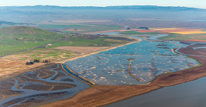
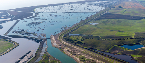
In 2015, the Sonoma Land Trust and Ducks Unlimited breached the levee at two locations, reuniting tidal flow to 960 acres of the site, restoring critical habitat for wildlife, and incorporating resilient features in the restoration design to help the site adapt to sea level rise.
Marsh mounds were constructed to reduce wind-wave energy and slow water flows to allow deposition of sediment that will elevate the marsh as sea levels rise. In addition, a sloped levee protects Highway 37, railroad tracks, and farmland from flooding, while providing transitional habitat for wildlife and refuge during storm events.
Marsh Mounds Objectives
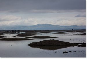 Reduce wind fetch, dampen associated wave-energy, and provide topographic relief in an otherwise flat, open tidal basin.
- Maximize sediment deposition to help raise the marsh from subsidence. Tides bring in water-borne sediment and marsh mounds slow water to help drop sediment and raise elevation over time.
- Create channels over time to restore hydraulic and ecological functions.
- Provide high tide refugia for wildlife. Mounds were not designed for this purpose at Sears Point, but other restoration project designs plan for this service, such as the Audubon California’s Sonoma Creek Project.
Design
- 500 marsh mounds were constructed using sediment excavated from channels created before the site was breached.
- Mounds were built to have 7:1 slopes and up to 70-foot diameter with a top elevation of the 6.5-foot, between mean seal level (MSL) and mean higher high water (MHHW).
- Mounds were sited in front of the levee to protect it as well as at randomly distributed locations throughout the site.
Construction
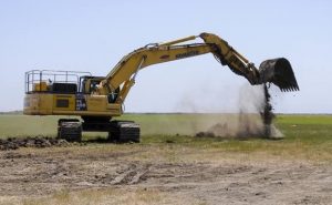 Much of the construction was relatively easy because the dry farmland the project site consisted of allowed contractors to drive on the fields, although high groundwater in some areas caused challenges for equipment.
Monitoring
- Monitoring of water quality, sedimentation, erosion, vegetative cover, and wildlife use will continue for 15 years (funding-dependent) and adaptive management measures are built in if objectives are not met. In addition, US Army Corps of Engineers is monitoring wave energy at two restoration sites, with and without marsh mounds.
Reduction of costs and risk
Like much of the north bay shoreline, the diking and subsidence of the Sears Point project area prevented seasonal rains from draining naturally into the bay. At a large annual expense, drainage ditches and pumping stations are maintained and operated on subsided lands to keep fields dry and prevent flooding of Highway 37 and railroad.
Costs: $18 million, 90% going to the tidal portions of the project and 10% to the upland portion
Timeline: Preliminary restoration plan, 2007; implementation, summer 2013; breach, 2015; Bay Trail open, 2016
Permitting: Two years needed to acquire permits as expected. A key to success was early establishment of good relationships with stakeholders such as the railroad, PG&E, and hunting clubs.
Partners: Sonoma Land Trust, Ducks Unlimited, US EPA, Federal Highway Administration, US Fish and Wildlife Service, NOAA, San Pablo Bay National Wildlife Refuge, Wildlife Conservation Board, Coastal Conservancy, CA Dept. of Water Resources, CA Dept. of Fish and Wildlife, Sonoma County Agricultural Preservation and Open Space District, Association of Bay Area Governments, Moore Foundation, Federated Indians of the Graton Racheria, Natioanl Fish and Wildlife Foundation, SF Bay Joint Venture
For more information: www.sonomalandtrust.org or contact Julian Meisler, Sonoma Land Trust (julian@sonomalandtrust.org; 707-526-6930)
Marsh Mounds at Other Locations: Sonoma Creek Enhancement Project (Audubon California)
 20 mounds (25 ft wide by 50-100 ft long) were constructed from freshly excavated soil from the project’s dredged channel.
- Two acres of high marsh fill was permitted for the marsh mounds and project design limited them to 8.4 feet tall so as not to convert tidal marsh to upland habitat.
- Mounds were expected to shrink 30% as waters drained from the soil, but measured rates were 50-60% due to exposure to sun/air and winter storm events.
- Marsh mounds were covered with pickleweed mats scraped from the channel footprint to expedite reveg
Photo credits: Stephen Joseph, Corby Hines, Sonoma Land Trust, Audubon California