Sonoma Creek Enhancement Project
Audubon California, USFWS, Coastal Conservancy, & many partners
Project Description
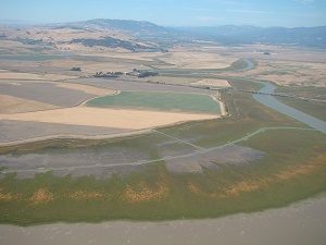 The Sonoma Creek Enhancement Project is improving a 260-acre area of tidal marsh that has been degraded from a levee built in the early 1900s that has collected gold rush era hydraulic mining and stagnated the marsh, causing it to have poor quality habitat for endangered and threatened species and foster high rates of mosquito production.
In this project, tidal flow was introduced into the marsh through the excavation of a 1-mile channel to Sonoma Creek, thus improving ecological function and reducing mosquito populations.
A habitat “transition ramp” was built, providing a gently sloped transition to a levee in place of a traditional levee design. This habitat transition ramp serves as a natural climate adaptation feature to provide flood protection while allowing habitats and species to migrate upslope as sea levels rise.
Habitat Transition Ramp
A gently-sloped habitat “transition ramp” from the tidal marsh to levee will:
- Act as a transitional zone to high marsh areas to allow species to migrate with rising sea levels.
- Reduce storm surge flooding and impact from wave run-up on the levee.
- Decrease saltwater intrusion through the existing levee.
- Provide high tide refuge for wildlife.
 Permitting fill of an existing wetland to create a transition ramp: To build the sloped habitat levee, the highest portion on the sloped levee (a 1-foot wedge) had to be converted from tidal marsh to upland habitat. Although “fill” of an existing wetland is not usually permitted in the bay, an experimental permit from the Bay Conservation and Development Commission (BCDC) was granted to create this resiliency feature for the project. Good partner relationships and communication were crucial to obtain a total of 7 permits needed for this innovative project.
Challenges working in an existing wetland: Working in an existing wetland provided challenges because species had to be flushed and the site weed-whacked immediately so no endangered or threatened species were harmed. Construction was limited to a 4-month window to accommodate both Ridgway’s rail nesting season and anadramous fish migration.
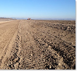
Construction
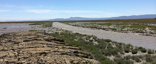
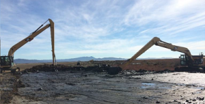 Sediment from channel excavation was used to construct the transition ramp along 2,300 feet of the levee with 40:1 – 60:1 slopes (6.74 acres).
- Planting on the transition ramp will commence in late 2016 or 2017 after the levee has had time to leach salt.
- After storms, the transition ramp has remained intact and will need minimal or no reshaping before planting.
- Working in an existing wetland proved challenging for construction because of the inaccessibility, indundation, and instability of the ground. A creative and innovative construction group was crucial to the project’s success.
- Contractors created a temporary floating road to access the marsh, built with drainrock and tarp and which sat 6 inches above water level.
Costs: $2.7 million, of which 70-80% went to contractors for physical construction. Buying materials to build the construction accessway on the marsh was a large cost.
Timeline: Five years to acquire permits (funding for pre-planning and the permit acquisition from EPA) and four months to construct in fall 2015
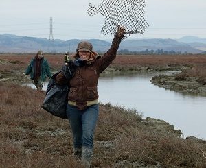
Monitoring: Pre-construction and post-construction monitoring of surface water hydrology, geomorphology, vegetation, soil accretion, photo points, endangered and threatened species (e.g., Ridgway’s rail), and other songbirds, shorebirds, and waterfowl
Partners: US Fish and Wildlife Service, Audubon California, Marin-Sonoma Mosquito Vector Control District, San Pablo Bay National Refuge, US EPA, Coastal Conservancy, CA Dept. of Fish and Wildlife, Wildlife Conservation Board, Vallejo Sanitation and Flood Control District, National Fish and Wildlife Foundation, Hanford ARC, ESA, Point Blue, and adjacent land manager
For more information: ca.audubon.org/conservation/conservation/seas-shores/san-francisco-bay/sonoma-creek-restoration, or contact Courtney Gutman, Audubon California (cgutman@audubon.org; 415-388-2524)
Transition Ramps at Other Locations: Sears Point Restoration Project (Sonoma Land Trust)
 A gradually sloping levee (10:1 – 20:1 slope) was constructed at Sears Point by Sonoma Land Trust that protects Highway 37, railroad, and farmland from flooding, while allowing the tidal marsh to migrate up slope with rising sea levels.
- Because raising a levee a small amount is very costly and the adjoining levees also need to be addressed in the future, the levee was not constructed for the worst-case scenario of sea level rise, but materials were stockpiled so that the levee could be raised up to 7 feet in the future. This allows the project to be adaptive and not stalled by extraordinary costs for a worst-case scenario.
Photo credits: Audubon California, Sonoma Land Trust