Rancho Cañada Floodplain Restoration Project
Monterey Peninsula Regional Park District (District) in collaboration with numerous federal, state, and local government agencies and non-profits, including the Coastal Conservancy, is working to restore and enhance floodplain connectivity and channel processes of the Carmel River at the Rancho Cañada unit of Palo Corona Regional Park, the site of the former 36-hole Rancho Cañada golf course. During its operational life, the golf course was the second highest water user on the Carmel River where in 2018, a consortium of conservation partners including the Trust for Public Land, Santa Lucia Conservancy, Trout Unlimited, the California Coastal Conservancy, and the Monterey Peninsula Regional Park District acquired the property for conservation recreational purposes.
The Rancho Cañada Floodplain Restoration Project (Project) will be the first major restoration effort at the park, where a one-mile section of the Carmel River will be restored so that natural processes will reconnect the river with historic floodplain habitat and create a mosaic of self-sustaining riparian habitat types and instream complexity.
- Approximately 3,200 linear feet of riprap will be removed to restore natural geomorphic processes (such as scour, deposition, and meander migration).
- Over 650,000 cubic yards of sediment will be excavated, which will lower the existing disconnected floodplains so that annual inundation can recur.
- Backwater channels and alcoves will be created within the new floodplain surfaces to create areas that will inundate at winter base flows, recreating critical areas of quiet water that will be available to aquatic species. In-channel gravel will be added to raise the water surface elevation upstream, helping push water into new floodplains.
- Three former golf cart bridges will be retired, eliminating a safety hazard and providing additional space for the Carmel River to migrate. One new pedestrian bridge will be constructed as part of the project, which will be rated for emergency vehicle access to support safe public access to 4,500 acres of Palo Corona Regional Park and the future segment of the California Coastal Trail extending into Big Sur.
Three existing bridges will be removed, eliminating a safety hazard and providing additional space for the Carmel River to migrate. One new pedestrian bridge will be constructed as part of the project, which will be rated for emergency vehicle access to support safe public access to 4,500 acres of Palo Corona Regional Park front ranch and backcountry areas.
The project is located on the site of the former 36-hole Rancho Cañada golf course. During its operational life, the golf course was the second highest water user on the Carmel River. In 2018, a consortium of conservation partners including the Trust for Public Land, Santa Lucia Conservancy, Trout Unlimited, the California Coastal Conservancy, and the Monterey Peninsula Regional Park District acquired the property for conservation purposes.

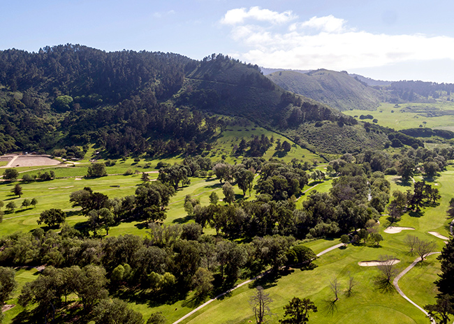
Rancho Cañada Floodplain Before

Rancho Cañada Floodplain After
The Project is particularly important for the federally threatened south-central California coast steelhead. The Carmel River watershed contains over one hundred stream miles of high-quality salmonid spawning grounds, but virtually no floodplain. A natural floodplain is vital habitat for the survival of salmonid fish, as it serves as a nursery and rearing area to grow and mature before returning to the ocean. Such habitat, which is flooded in the wet season and typically supports robust riparian vegetation, provides far more food for young-of-the-year fish than the main part of the river. The floodplain also provides a slow-water refuge during high flow events and can also help recharge the groundwater and reduce flooding in adjacent areas. The Project implements the recommendations of the Steelhead Recovery Plan, issued by the National Oceanic and Atmospheric Administration’s National Marine Fisheries Service (NOAA Fisheries).
The river is disconnected from its floodplains by near vertical banks that rise as high as 15 feet above the channel which prevent recruitment of new riparian vegetation on the historic floodplain and simplification of the river corridor. Changes to upstream sediment transport processes, resulting from both the removal of the San Clemente Dam and a series of major fires over the past 5 years, have resulted in significant sediment loads coming from the upper watershed that create an elevated flood risk for neighboring communities. Lowering the floodplain surrounding the river and providing a safe place for the river to fan out and deposit sediment helps mitigate that flood risk to surrounding communities. These lowered and gradually sloping floodplains also provide more space for the river and floodwaters to move, building resilience to varying future hydrology with climate change.
The total restoration project cost is estimated at $35 million. Funding secured to-date:
-
- $10 million from the National Fish and Wildlife Foundation’s National Coastal Resilience Fund
- $6 million from National Oceanic and Atmospheric Administration (NOAA)’s Office for Coastal Management
- $13 million from the Wildlife Conservation Board
- $6 million from the California State Coastal Conservancy
Project partners include the Monterey Peninsula Regional Park District, California State Coastal Conservancy, US Fish and Wildlife Service, National Oceanic and Atmospheric Administration’s National Marine Fisheries (NOAA Fisheries), California Department of Fish and Wildlife, Regional Water Quality Control Board, California State University Monterey Bay, Trust for Public Land, Monterey Peninsula Water Management District, Trout Unlimited, and the Carmel River Task Force.
An initial outreach meeting was held on the evening of March 9, 2022. A recording of the meeting can be found here.
To receive project updates, sign up for our mailing list here.
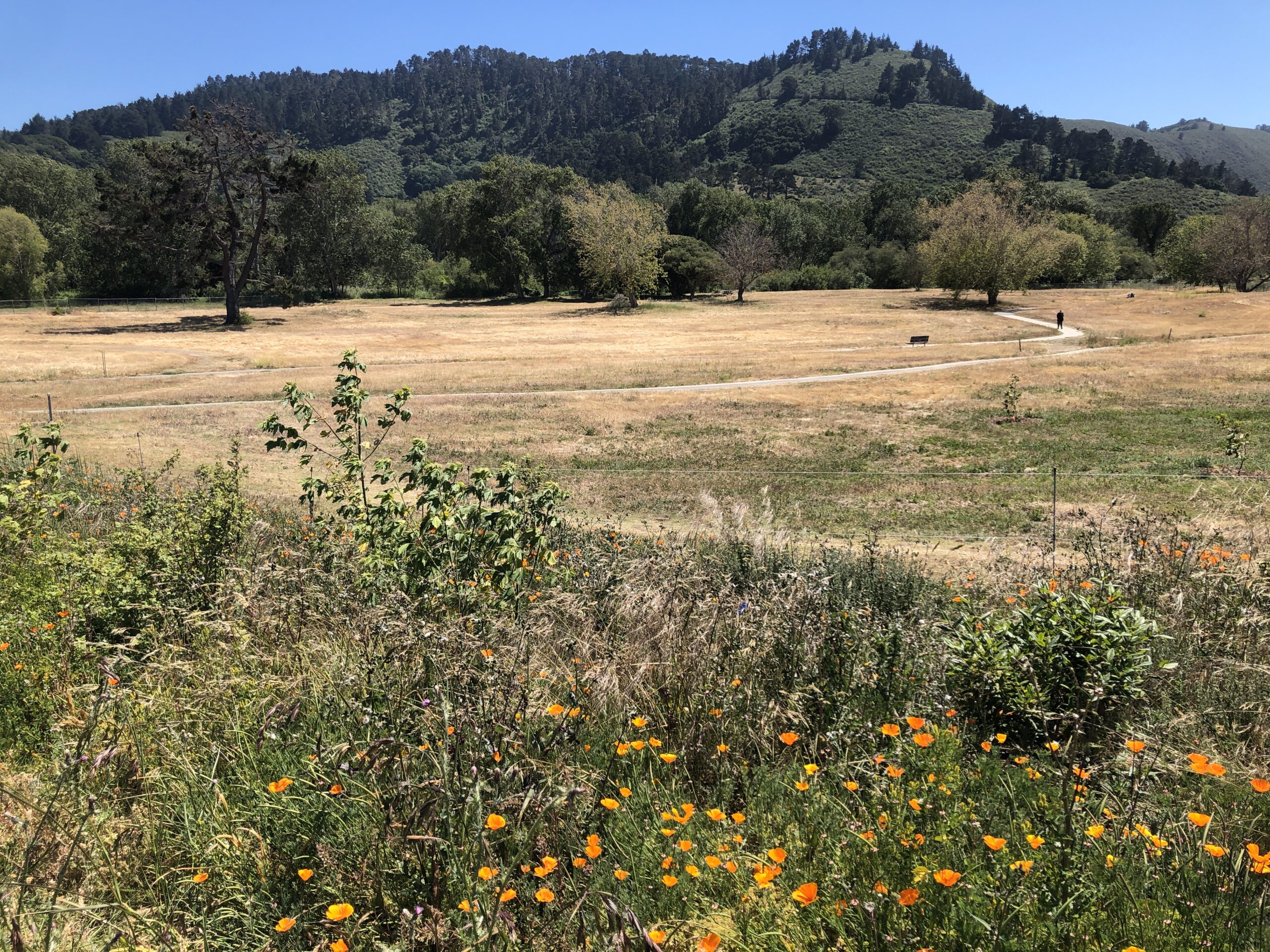
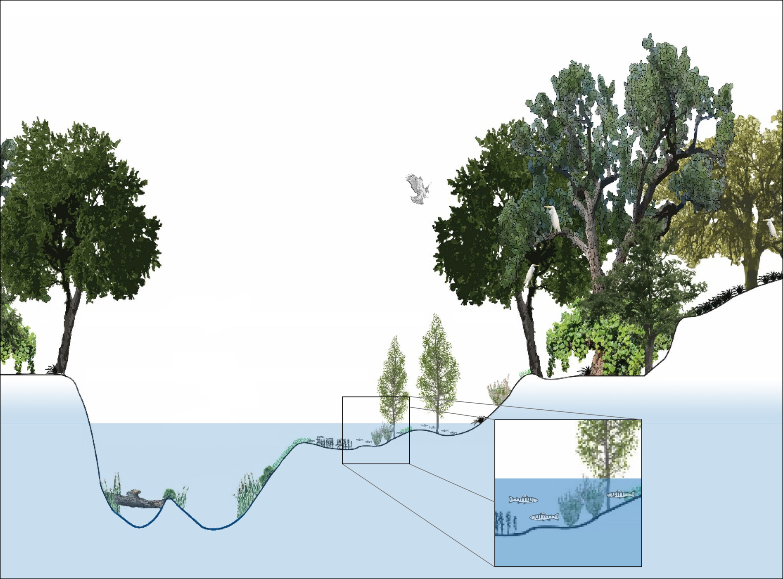
Illustration of inundated floodplains and fish rearing
Project Contacts
Katrina Harrison
McBain Associates, Applied River Sciences
Water Resources Engineer
katrina (at) mcbainassociates.com
Rachel Couch
State Coastal Conservancy
Project Manager
rachel.couch (at) scc.ca.gov
Jake Smith
Monterey Peninsula Regional Park District
Planning & Conservation Program Manager
jsmith (at) mprpd.org
To receive project updates, sign up for our mailing list here.