Highway 37 and the San Pablo Baylands

Photo courtesy of Sonoma Land Trust
State Route (SR) 37 is a 21-mile highway that runs from Highway 101 in Novato to Highway 80 in Vallejo, crossing Marin, Sonoma, Napa and Solano Counties. Dubbed the “Flyway Highway”, it crosses marshes and ponds that support millions of waterfowl stopping to rest and forage before continuing their journey on the Pacific Flyway, a migratory corridor extending from the Arctic tundra to South American wetlands. Many partners have invested over $600 million in acquisition, restoration and enhancement of roughly 30,000 acres of the San Pablo Baylands to advance the goals set by the ecological restoration community.
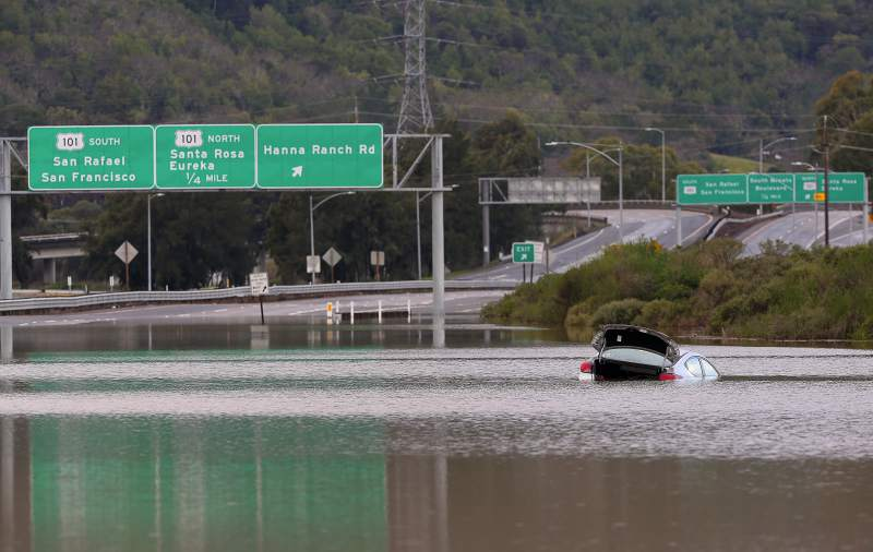
Photo courtesy of The Press Democrat
As flooding in 2017 and 2019 that closed the highway revealed, SR 37 is highly vulnerable to both near-term flooding and permanent inundation due to sea level rise. The road is also severely congested, particularly along a two-lane segment from Highway 121 in Sonoma County to Mare Island in Solano County.
In 2015, the transportation authorities of Marin, Napa, Solano and Sonoma Counties agreed to form a partnership through a Memorandum of Understanding (MOU) to develop an expedited funding, financing and project implementation strategy for the reconstruction of SR 37 to withstand rising seas and storm surges while improving mobility and safety along the route. The Metropolitan Transportation Commission and Caltrans were later added to the MOU. The officials representing these local, regional, and state transportation interests meet regularly as the SR 37 Policy Committee. Caltrans, the Metropolitan Transportation Commission, and the four county transportation authorities are now working together as a team on short-term fixes and a long-term solution for the corridor. For more information, visit the Resilient SR 37 page.
SR 37–Baylands Group
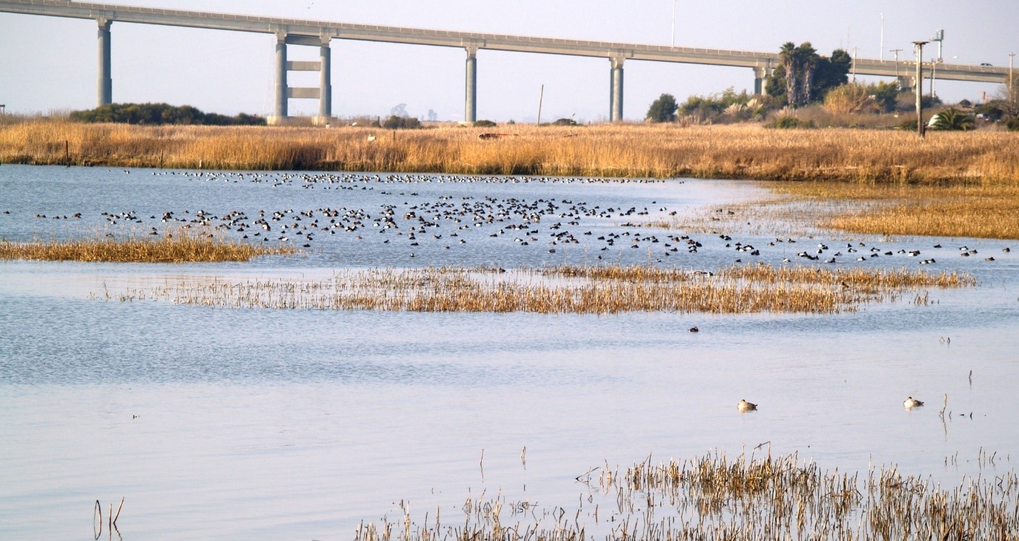
Photo courtesy of Ducks Unlimited
In June 2017, in response to the acceleration of plans to redesign and rebuild SR 37, the Sonoma Land Trust convened a group composed of North Bay wetland land managers, ecological restoration practitioners, and other stakeholders interested in the conservation and restoration of the San Pablo Baylands. The group, now known as the SR 37–Baylands Group, reached consensus that the redesign of SR 37 represents both a major opportunity and potential threat to North Bay ecosystems, particularly in light of future sea level rise.
The Coastal Conservancy was asked to provide regional leadership for this group. The Conservancy plays three main roles:
- Long-term funder of San Pablo Baylands conservation and restoration work;
- Coordinator of the SR 37-Baylands Group; and
- Promoter of collaboration with transportation and regulatory agencies.
The Baylands Group’s purpose is to ensure that the redesign of SR 37 is compatible with and advances the ecological restoration and conservation goals for the San Pablo Baylands and improves the climate resilience of both the built infrastructure and natural ecosystems.
Vision of the SR 37 – Baylands Group:
Integrate infrastructure improvements for SR 37 with existing and future habitat planning, conservation and restoration to ensure healthy ecosystem function and resilience to landscape scale change of the San Pablo Bay.
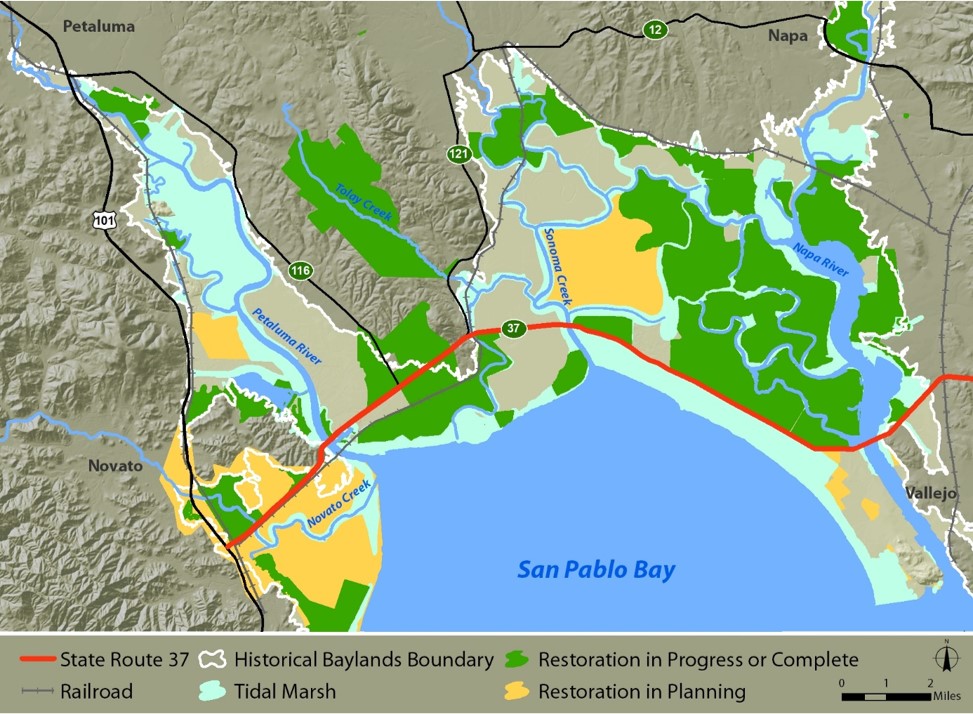
Map of Restoration to Date and Planned
Accomplishments to Date
The SR 37-Baylands Group has made progress toward achieving the following goals:
- Creating and Promoting Adoption of Our Guiding Principles. The SR 37-Baylands Group produced a white paper that included guiding principles.
- These principles were incorporated into the final SR 37 Transportation and Sea Level Rise Corridor Improvement Plan that was released in February 2018.
- The principles are also being used as the basis of evaluation criteria for the MTC-led State Route 37 (SR 37) Resilient Corridor Program for Marin and Sonoma Counties, which produced Design Alternatives Assessments for the segments of SR 37 running from Highway 101 to Highway 121 (2019) and from Highway 101 to Highway 121 (2022).
- The principles were included in an adapted form in the “Purpose and Need Statement” for the Caltrans-led Planning and Environmental Linkages (PEL) Study for SR 37 from US 101 to I-80 (ongoing).
- Influencing Transportation and Public Access Planning. Members of the SR 37-Baylands Group have influenced several transportation and public access planning processes for the SR 37 corridor.
- Based on our input and thanks to visionary leadership at MTC, what was a transportation project has become the Resilient 37 Transportation Corridor Program that includes equity, ecology, and public access, as well as sea level rise adaptation.
- Baylands Group experts helped MTC identify the pile-supported causeway as having less environmental impact than a hybrid design of causeway and embankment in the State Route 37 Ultimate Sea Level Rise Resilience Design Alternatives Assessment Report (February 2022). This assessment also demonstrates that alternative alignments either did not meet the purpose and need or had even greater environmental impacts.
- Based on our input, the SR 37 Public Access Scoping Report (June 2020) acknowledges need to protect “Core Wildlife Areas” and proposes only public access that is compatible with wildlife in those areas.
- Developing an Ecological Landscape Vision. Baylands Group members have promoted greater understanding of ecological connectivity and led the development of watershed-based conservation strategies for the San Pablo Baylands.
- Conceptual map of ecological connectivity in the San Pablo Baylands (below)
- Sonoma Creek Baylands Strategy (May 2020)
- Petaluma River Baylands Strategy (In progress)
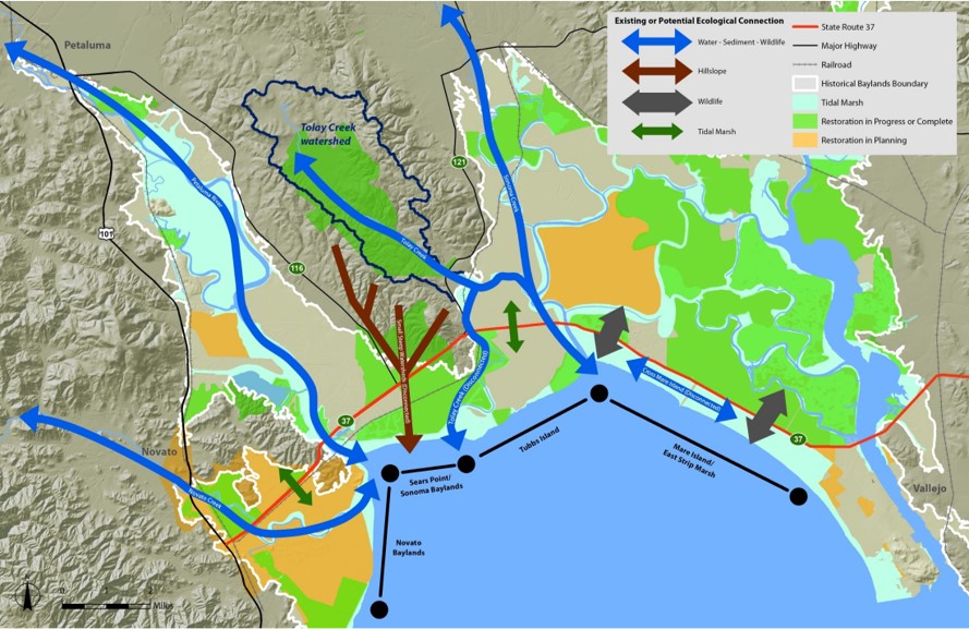
Conceptual Map of Ecological Connectivity
The redesign of Highway 37 presents an opportunity to restore ecological connectivity that is restricted by the current highway. This includes:
- hydrologic connectivity (blue arrows) needed to support wetland processes, such as sediment transport to enable marshes to keep up with sea level rise;
- reconnection of major tributaries (Napa River, Sonoma Creek, Novato Creek, Tolay Creek, and Petaluma River) to the tidal wetlands (brown arrows) to facilitate sediment transport and enable marsh migration into upland areas;
- connections among tidal marshes currently separated by the highway (green arrows) needed to restore a broad, continuous swath of habitat; and
- connectivity needed by wildlife (gray arrows) that are currently unable to cross the road.
Current Work
The SR-37 Baylands Group has stated that although the planning for the new design may be done in segments, it is essential that planning for the corridor be North Bay-wide to capture the breadth of ecological processes in the region, including the contribution from upland habitats, rather than focusing solely on the area immediately adjacent to the SR 37 corridor. We are pleased to report progress toward this goal:
- Caltrans is leading a State Route 37 Planning and Environmental Linkages (PEL) Study for the entire corridor.
- MTC is leading the development of the North Bay Baylands Regional Conservation Investment Strategy.
- The SR 37-Baylands Group has released a position paper supporting a pile-supported causeway along the current alignment.
The SR 37-Baylands Group continues to engage with the transportation agencies in promoting integration of ecological protection, restoration, connectivity, and resilience as part of these ongoing corridor planning processes.
Bayland Group Documents
- Baylands Group SR 37 Position Paper, July 2022
- White Paper: San Pablo Baylands: Ensuring a Resilient Shoreline
- Comment Letter: SR 37-Baylands Group Comments on the Draft SR 37 Transportation and Sea Level Rise Corridor Improvement Plan
- Reflections on the SR 37 Segment B Planning Process to Date
- Presentation: Sea Level Rise Adaptation for State Route 37: The Flyway Highway, January 2021
Related Information
- State Route 37 Ultimate Sea Level Rise Resilience Design Alternatives Assessment Report, Executive Summary
- State Route 37 Policy Committee
- Highway 37 Stewardship Project
- Caltrans Transportation Concept Report for State Route 37
- Water Board Design Alternatives Guidance and Permitting Requirements for Highway 37 Between U.S. 101 and Interstate 80
- U.S. Environmental Protection Agency Letter on Early Coordination for the Highway 37 Project
- SPUR Letter on Highway 37 Planning, Alignment and Design Considerations
For More Information:
Jessica Davenport
Deputy Program Manager
State Coastal Conservancy
Latest News
- Job Posting: Deputy Executive Officer C. E. A.“Love the California Coast, the environment, supervising people, and public agency management? This might be the job for you!” The State Coastal Conservancy is seeking an experienced leader to join our Executive Management team as the Deputy Executive Officer, CEA, range A. Reporting to and assisting the Executive Officer, the Deputy Executive Officer develops and […] (Read more on Job Posting: Deputy...)
- Press Release: State, Regional Agencies Join Forces to Prepare Bay Area for Sea Level Rise, Increased FloodingMemorandum Marks Commitment to Coordinated Efforts SAN FRANCISCO, July 22, 2024… Seven regional and state public agencies have executed a new memorandum of understanding committing each agency to a joint work program to address increased threats of flooding and sea level rise in the nine-county San Francisco Bay Area region. The agencies participating in the […] (Read more on Press Release: State,...)
- San Francisco Bay Area Water Trail Implementation Meeting #42 – June 21, 2024, 10am – 12pmAGENDA June 21 , 2024 10:00 a.m. – 12:00 p.m. VIRTUAL MEETING Zoom Meeting Information: Please join us on Zoom at this link: https://scc-ca-gov.zoom.us/meeting/register/tZEtcumrqTMrHdeYKO2888Cqs7e8id82p4VD Desired Outcomes of Meeting: Attendees are informed of Water Trail-related activities, progress, and accomplishments Attendees are informed about a new water access audio tour from guest speaker Attendees are informed of […] (Read more on San Francisco Bay...)

 Help Save Sea Otters at Tax Time